APEX HUNT by Field Armor
The Apex Hunt app icon: a grouse in flight on dark green

APEX HUNT

BY FIELD ARMOR · FIELD-TESTED IN MICHIGAN

Every stand of public forest, scored for grouse and woodcock. On a map that works with no signal.

Apex reads the state and federal forest inventory (the cover type, the age, the canopy, the forester's own notes) for every stand of public land in Michigan, Wisconsin and Minnesota, with more states being added, and puts a number on each covert. Then it tells you which stand to walk first, and which way to walk it.

$4.99/month after the trial. Cancel any time. The map, your journal and the plant guide stay free, always.

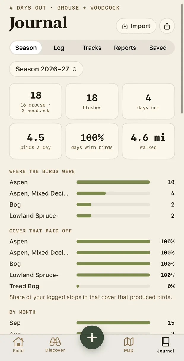
The Season page: 18 birds this season (16 grouse and 2 woodcock), 18 flushes, 4 days out, 4.5 birds a day, 100 percent of days with birds, 4.6 miles walked, and where the birds were: Aspen 10, Aspen and mixed deciduous 4.
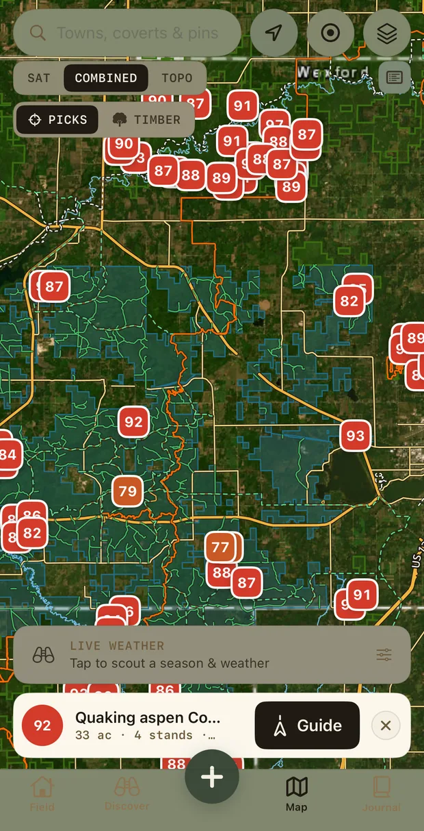
The Apex map near Houghton Lake, Michigan: public land shaded over satellite imagery, every covert marked with its score (87, 90, 92, 93), and one selected: Quaking aspen covert, 92, with a Guide button
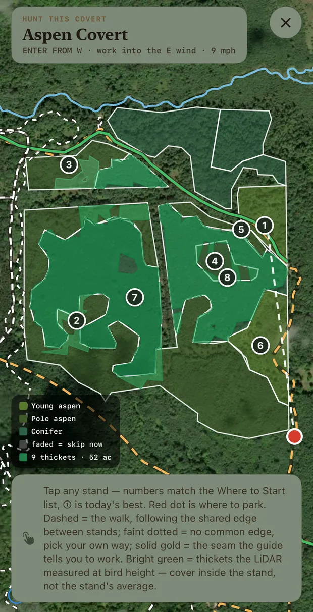
Hunt this covert: eight numbered stands over satellite imagery in shades of green, enter from the west into the east wind, a red dot where to park, and the dashed walking line.

WHERE THE NUMBERS COME FROM

Habitat intelligence, not a feed of pins.

A score is a rule about the woods, applied to public records: the same compartment reviews the foresters write. A 78 means strong habitat right now. It doesn't promise a bird; hunt a 78 ten times and you'll move more birds than on a 40.

232,525
inventoried stands across MI, WI and MN
23,154
coverts: neighbouring stands worth a morning together
LiDAR
understory measured at bird height, wherever it has flown
117,000
forester's notes, shown verbatim

WHAT IT DOES

It doesn't show you pins. It shows you cover.

Other apps put a dot where somebody once shot a bird. Apex scores the woods themselves, from the same compartment reviews the foresters write, so a good covert is a good covert whether or not anyone has told the internet about it.

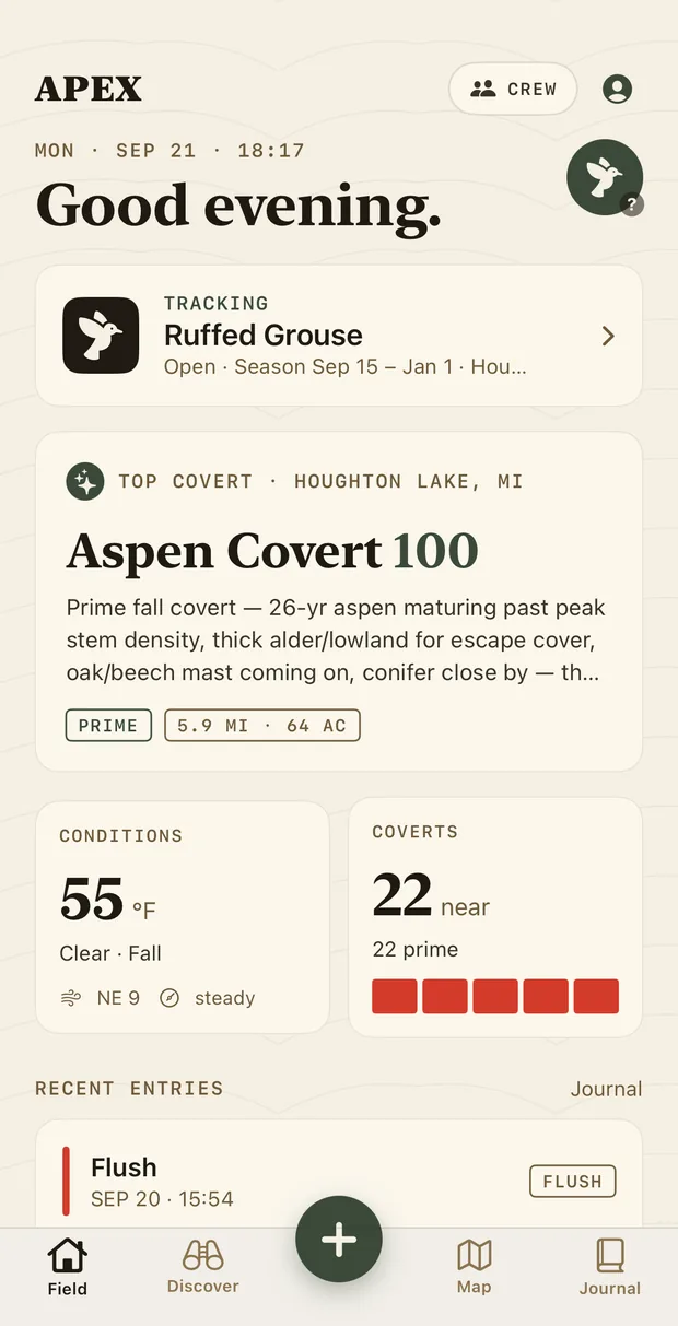
The Field screen: Good evening. Tracking Ruffed Grouse, season Sep 15 to Jan 1. Top covert near Houghton Lake: Aspen Covert, 100: prime fall covert, 26-year aspen maturing past peak stem density, thick alder lowland for escape cover, oak and beech mast coming on, conifer close by. Prime, 5.9 miles, 64 acres. Conditions 55°F clear, NE 9, steady. 22 coverts near, 22 prime.

OPEN IT

Tonight's best covert, and why.

The Field screen is the brief. Your top covert for the conditions right now, in a sentence a hunter would write: “26-yr aspen maturing past peak stem density, thick alder/lowland for escape cover, oak/beech mast coming on, conifer close by.” Distance, acreage, the weather, how many coverts are near and how many are prime. Then your last entry, so the journal is one tap away.

HUNT IT

Numbered stands. Which way to walk in. Where to park.

Open a covert and Apex draws every stand inside it over the satellite, coloured by what it is (young aspen, pole aspen, conifer), and numbers them in the order to hunt. ① is today's best. The red dot is where to park. The dashed line is the walk, along the shared edge between stands; the gold seam is the transition the guide tells you to work. Enter from the W, work into the E wind, 9 mph. It says so at the top.

The bright green isn't the stand's average. It's the thickets the LiDAR measured at bird height: cover inside the stand, where the birds actually are.

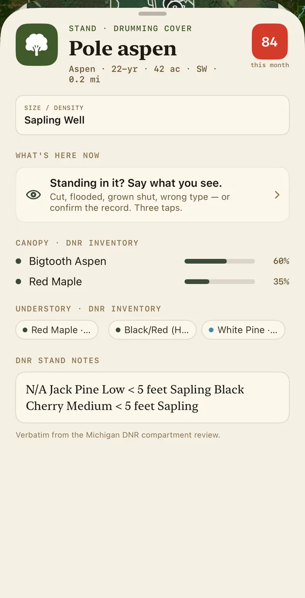
Tap a stand and you get the forester's record: canopy by species and percent, the understory, the size and density class, and the DNR's own notes, verbatim. Standing in it and it's been cut, flooded or grown shut? Say so in three taps and your map learns.

Hunt this covert: Aspen Covert, enter from W, work into the E wind, 9 mph. Eight numbered stands drawn over satellite in green shades (young aspen, pole aspen, conifer), with a red dot where to park, a dashed walking line and a legend: 9 thickets, 52 acres, faded means skip now.
A stand sheet: Pole aspen, drumming cover, 22 years, 42 acres, SW 0.2 miles, scored 84 this month. Size and density: sapling, well stocked. Canopy from the DNR inventory: bigtooth aspen 60 percent, red maple 35 percent. Understory: red maple, black and red oak, white pine. DNR stand notes verbatim from the Michigan compartment review.

SCOUT IT

Dial in October. Or a post-front morning in November.

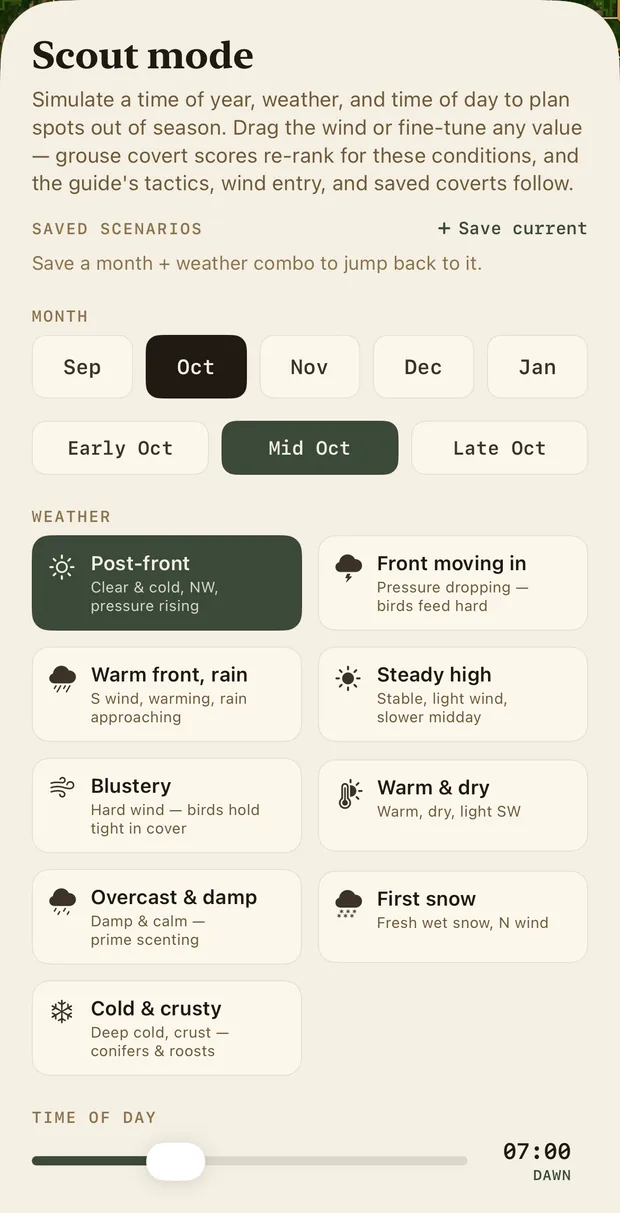
Scout mode re-ranks every covert for a season, a weather scenario and a time of day you choose (mid October, post-front, dawn), so you can plan a trip in August and know which coverts will be worth it when the leaves are down. Drag the wind and the entry plan turns with it. Save a scenario and jump back to it.

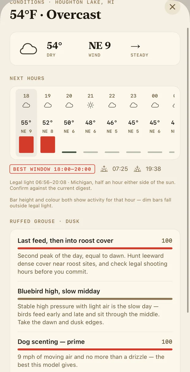
On the day, the conditions sheet does the same with the real forecast: the hour-by-hour strip, the best window (18:00–20:00), legal light, and what it means for the bird: last feed, then into roost cover; bluebird high, slow midday; dog scenting — prime.

Scout mode: simulate a time of year, weather and time of day to plan spots out of season. Month: Sep, Oct, Nov, Dec, Jan; early, mid, late October. Weather scenarios: post-front, front moving in, warm front rain, steady high, blustery, warm and dry, overcast and damp, first snow, cold and crusty. Time of day slider at 07:00 dawn. Wind: drag to plan your entry.
Conditions at Houghton Lake: 54°F overcast, NE 9 wind, steady pressure. Next hours with temperature and wind. Best window 18:00 to 20:00. Legal light 06:56 to 20:08. Ruffed grouse at dusk: last feed then into roost cover, 100; bluebird high, slow midday; dog scenting prime, 100.

LOG IT

Every flush sharpens your map. And stays on your phone.

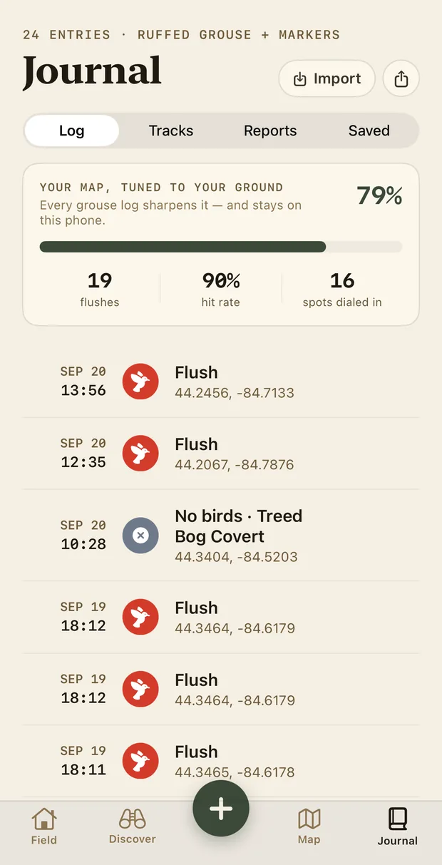
Log a flush, a brood, drumming, or a blank, and Apex tunes its scores to your ground. The journal shows how far along that is (79%, tuned to your ground), your flushes, your hit rate, the spots you've dialed in. It runs on the phone. Nothing about where you hunt goes anywhere unless you send it.

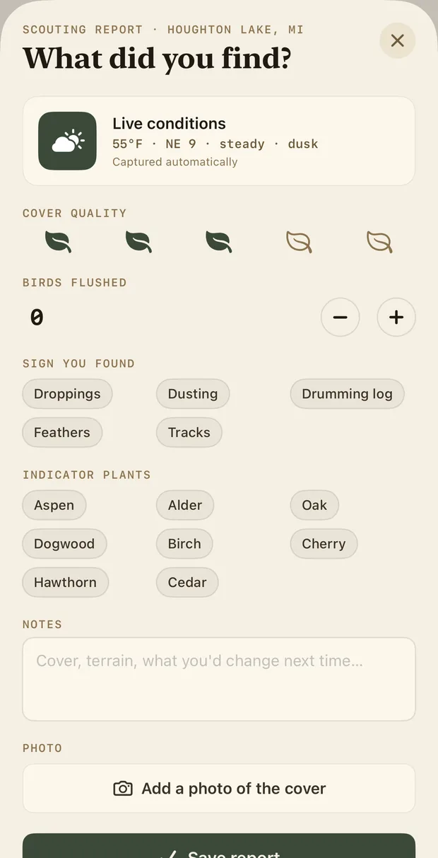
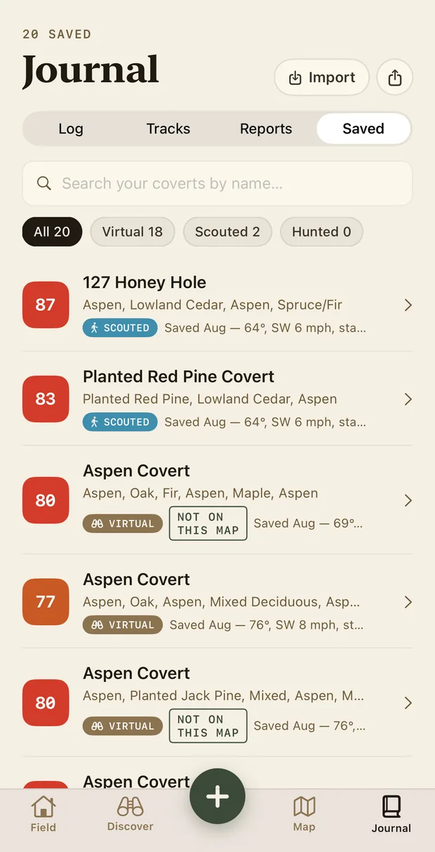
A scouting report takes a minute: cover quality, birds flushed, the sign you found (droppings, dusting, a drumming log), the indicator plants, a note, a photo. The live conditions are captured for you. Saved coverts are sorted virtual, scouted, hunted, so you know which of your twenty you've actually walked.

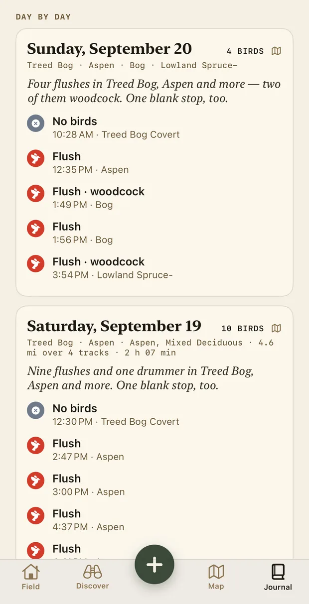
The journal: 24 entries, ruffed grouse and markers. Your map, tuned to your ground: 79 percent; every grouse log sharpens it, and stays on this phone. 19 flushes, 90 percent hit rate, 16 spots dialed in. Entries: Flush, Sep 20 13:56; Flush, Sep 20 12:35; No birds, Treed Bog Covert, Sep 20 10:28.
Scouting report, Houghton Lake: what did you find? Live conditions captured automatically, 55°F NE 9 steady, dusk. Cover quality as five leaves. Birds flushed. Sign you found: droppings, dusting, drumming log, feathers, tracks. Indicator plants: aspen, alder, oak, dogwood, birch, cherry, hawthorn, cedar. Notes. Add a photo of the cover. Save report.

YOUR SEASON

How did the season go, and where were the birds?

A list of pins isn't a journal. The Season page reads your log back to you: birds split grouse and woodcock, flushes, days out, birds a day, the share of days that produced birds, and the miles you walked to get them.

Then the part a list can't show you. Where the birds were: every flush matched to the cover it came out of. Cover that paid off: the share of your stops in each cover that moved a bird. And every day written out in a sentence: "Four flushes in Treed Bog, Aspen and more — two of them woodcock. One blank stop, too."

The scouting desk shows the same season on a big screen, down to the week, the day, or any days you pick, with the weather you hunted in.

The Season page for 2026–27: 18 birds (16 grouse, 2 woodcock), 18 flushes, 4 days out, 4.5 birds a day, 100 percent of days with birds, 4.6 miles walked. Where the birds were: Aspen 10, Aspen and mixed deciduous 4, Bog 2, Lowland spruce 2. Cover that paid off: Aspen, Aspen and mixed deciduous, Bog and Lowland spruce 100 percent, Treed bog 0. By month: September 15.
Day by day: Sunday, September 20, 4 birds in Treed Bog, Aspen, Bog and Lowland spruce: four flushes, two of them woodcock, and one blank stop, with each stop and its time. Saturday, September 19, 10 birds over 4.6 miles on 4 tracks in 2 hours 7 minutes: nine flushes and one drummer.

READ IT

What to look for. What it's doing this month. Why the bird cares.

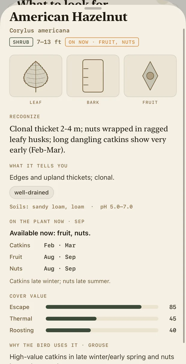
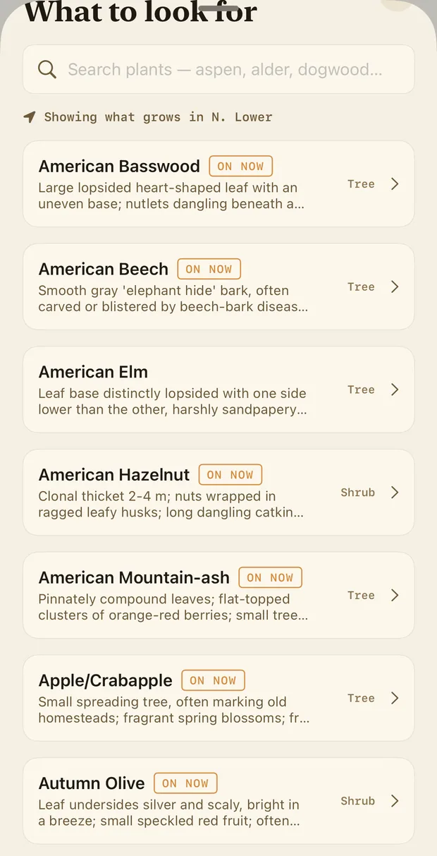
The plant guide is written for a grouse hunter, not a botanist. It shows what grows where you are (showing what grows in N. Lower) and what's ON NOW. Open American hazelnut and you get how to recognise it in September, what the site tells you (edges and upland thickets; clonal), what's on the plant this month (fruit, nuts), its value as escape, thermal and roosting cover, and the reason it matters: high-value catkins in late winter, nuts in good years, dense escape cover.

Every covert lists what you should find in it, by stand, so when the guide says hawthorn, you know which corner to check.

Plant guide: American Hazelnut, Corylus americana, shrub, 7 to 13 feet, on now: fruit, nuts. Recognise: clonal thicket 2 to 4 metres, nuts wrapped in ragged leafy husks, long dangling catkins show very early. What it tells you: edges and upland thickets, well-drained, sandy loam. On the plant now, September: fruit, nuts. Cover value: escape 85, thermal 45, roosting 40. Why the bird uses it: high-value catkins in late winter and early spring, nuts in good years, dense escape cover.
What to look for: a searchable plant list showing what grows in the northern Lower Peninsula, each marked ON NOW where it is: American basswood, American beech, American elm, American hazelnut, American mountain-ash, apple and crabapple, autumn olive.

GET THERE

Turn-by-turn on the trails. Drop a pin in two taps.

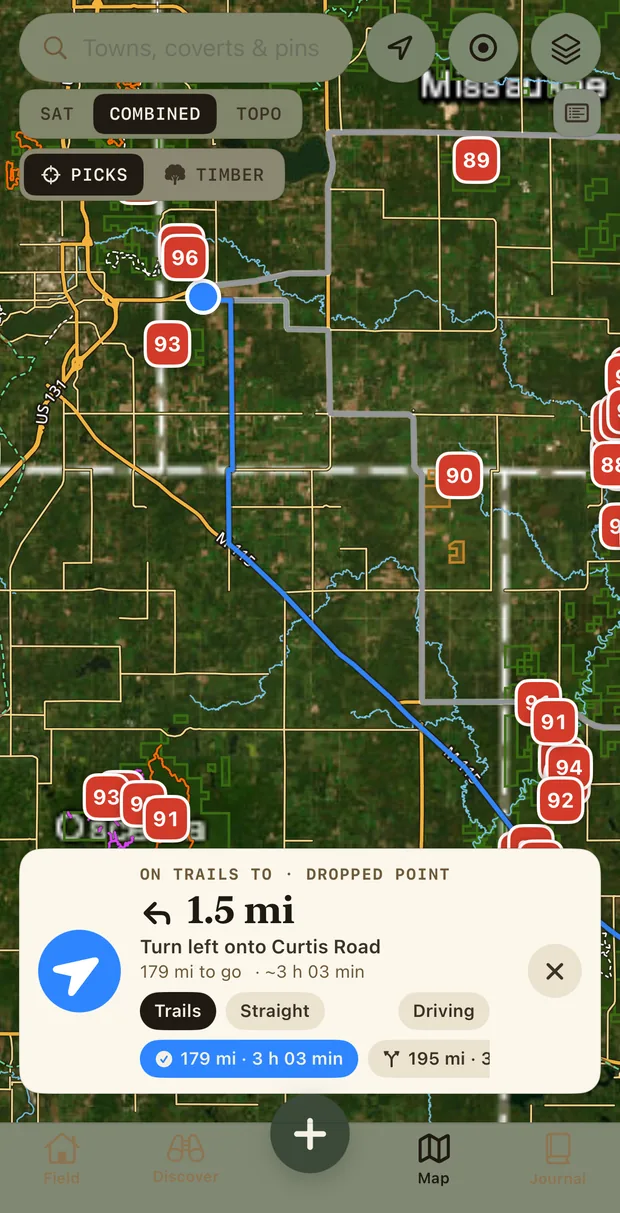
Apex carries its own roads and trails (county roads, forest roads, the two-tracks and snowmobile trails the DNR maps) and routes on them: on trails to your dropped point, turn left onto Curtis Road. Trails, straight-line or driving, with the distance and time for each. Or hand it to Apple Maps for the drive.

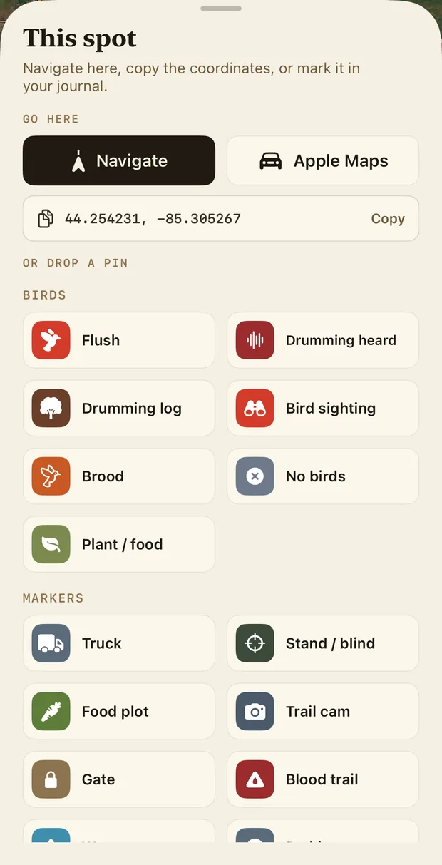
Long-press anywhere for a pin: flush, drumming heard, brood, bird sighting, no birds. Or a marker: the truck, a gate, a stand, a food plot, a trail cam, a blood trail. Copy the coordinates for anyone who needs them.

Navigation on the map: a route drawn along trails to a dropped point. On trails to dropped point, 1.5 miles, turn left onto Curtis Road, 179 miles to go, about 3 hours 3 minutes. Options: trails, straight, driving.
This spot: navigate here, open in Apple Maps, or copy the coordinates 44.254231, -85.305267. Or drop a pin. Birds: flush, drumming heard, drumming log, bird sighting, brood, no birds, plant or food. Markers: truck, stand or blind, food plot, trail cam, gate, blood trail.
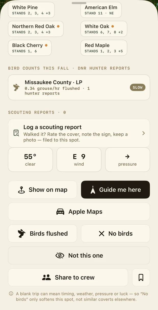
A covert's actions: what you should find here by stand: white pine, American elm, northern red oak, white oak, black cherry, red maple. Bird counts this fall from DNR hunter reports: Missaukee County, 0.34 grouse per hour flushed, slow. Log a scouting report. Show on map, Guide me here, Apple Maps, Birds flushed, No birds, Not this one, Share to crew.
Saved coverts: 20 saved, filtered all, virtual 18, scouted 2, hunted 0. 127 Honey Hole, scouted, 87. Planted Red Pine Covert, 83. Aspen Covert, 80, virtual.
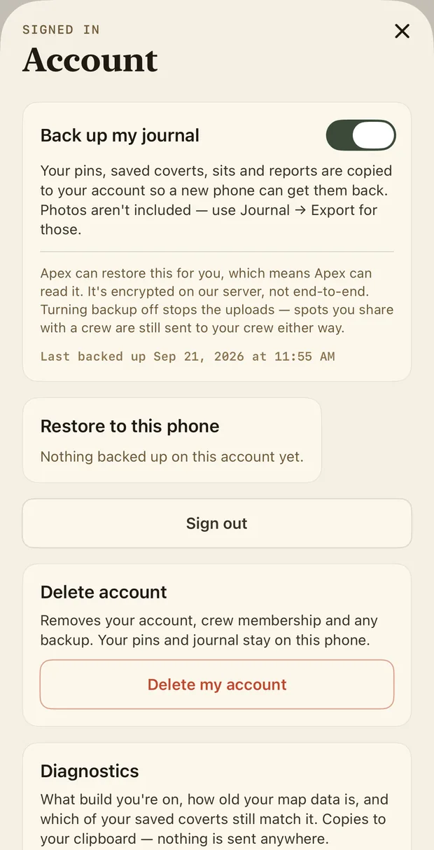
Account: Back up my journal is a switch. Your pins, saved coverts and reports are copied to your account so a new phone can get them back; photos aren't included. Restore to this phone. Sign out. Delete account.

AND

  • The DNR's own bird counts for the county you're standing in, from the hunter-report dashboard (0.34 grouse/hr flushed · slow), beside every covert.
  • Share to crew. Your hunting party on one map: shared spots, live location when you choose to turn it on, and a chat for when there's a bar of signal. Nobody outside your crew sees any of it.
  • Backup is a switch, and it's off. Your pins, saved coverts and reports stay on your phone unless you flip it. Delete your account and everything on our side goes with it.

APEX PRO

One plan. Two ways in.

$4.99 a month for PICKS, the full stand inventory, the guide and Crew. Michigan, Wisconsin and Minnesota are included, and more states are being added.

THROUGH FIELD ARMOR

30 days freethen $4.99/month

  • Billed by Field Armor on fieldarmorusa.com
  • Cancel any time in your Field Armor account
  • Sign in to the app with the same email, and Pro comes with it
Start 30-day free trial

ON IPHONE

14 days freethen $4.99/month

  • Subscribe inside the app, billed by Apple
  • Cancel in Settings › Apple ID › Subscriptions
  • Sign in with Apple or your Field Armor email
Get it on iPhone

One subscription is all you need, so don't buy both. A card is required to start the Field Armor trial; you're not charged until day 31.

START YOUR 30-DAY FREE TRIAL

Your email is your account.

No password. We email you a six-digit code. Then you'll finish checkout on fieldarmorusa.com.

Questions

Who makes Apex Hunt?

Field Armor, the upland outfitter behind the Field Armor dog vests, at fieldarmorusa.com. Apex Hunt is our app, built and field-tested in Michigan.

What's free, and what does Pro add?

Free, always: the map with roads, trails and public land, your pins and recorded tracks, the journal and the plant field guide. Pro adds PICKS (scored coverts on the map and ranked in Discover, with the guide for each), TIMBER (every stand in the state to browse and filter) and Crew.

What happens when my trial ends or I stop paying?

Pro features lock. Nothing is deleted. Your journal, pins, tracks and saved coverts stay on your phone and keep working, and so do the map and the field guide. Subscribe again and Pro comes straight back.

How do I cancel?

If you subscribed on iPhone: Settings › your name › Subscriptions › Apex Pro. If you subscribed through Field Armor: sign in on fieldarmorusa.com and cancel under your subscriptions. Either way, Pro stays on until the end of the period you've paid for.

Why is there no password?

Because a password is one more thing to forget and one more thing to steal. Sign in with Apple, or with a one-time code we email you. Apex never asks for or stores a password.

Which states does it cover?

Michigan, Wisconsin and Minnesota: state forest, national forest and state game and wildlife areas, with more states being added. One subscription covers them all.

Can I plan on a bigger screen?

Yes. Pro includes the scouting desk at api.apexhunt.app/app: the same coverts, scores and stand inventory in your browser, with your journal and crew, for planning at the kitchen table. Sign in with the same email.

Does it work with no signal?

Yes. The coverts, stands and scores are stored on your phone and ranked on your phone. Download the map for your area over Wi-Fi before you go and the imagery comes with you.

Is the public-land boundary exact?

No, and nothing built from agency data is. Boundaries are generalised and can be wrong at the edges; ground shown as public may be private, leased or closed. What's posted on the ground controls; see §3 of the Terms.

Where are my spots stored?

On your phone. They leave it only if you share them with a crew or turn on backup. See the privacy policy for exactly what we keep.

The Apex Hunt splash screen: the grouse icon, APEX HUNT by Field Armor, field-tested, Michigan

FIELD-TESTED · MICHIGAN

Built by hunters who kept asking the same question.

Which of these ten thousand acres is worth a morning? Apex is the answer we wanted on our own phones: the forester's records, the laser's measurements and our own logs, in one place, working where the signal isn't.